
By Thane Grauel
WESTPORT — Sea levels are expected to rise a foot and half by 2050. Expect continued damage from hurricanes, windstorms and storm-surge flooding. The town’s population might drop by almost 7,000 people — 23.9 percent — over the next two decades.
These are among the dour projections contained in a more-than-200-page document entitled the “WestCOG Multi-Jurisdictional Hazard Mitigation Plan,” adopted unanimously Wednesday morning by the Board of Selectmen.
The plan has been in existence for some time, but recently had its third five-year update, which is being approved by 18 towns from Greenwich to Westport on the coast, as well as those north into Litchfield County — all of which make up WestCOG — the Western Connecticut Council of Governments.
The plan identifies issues that need to be addressed before events such as natural disasters, terrorist attacks or mass-casualty incidents occur.
Each town can use the document to determine its priorities, but adopting the plan makes municipalities eligible for certain federal grants and other programs.
“We can’t get grants unless we have a hazard mitigation plan in place,” Conservation Director Alicia Mozian told the Board of Selectmen. “I would say from an economic standpoint that’s the number one thing.”
“In the last week I’ve come across two projects that could benefit from money like this,” she said.
Among those are replacement of the valve flaps that operate into the Compo basin area.
“That’s a possible grant-funding project,” Mozian said.
Another project could be acquisition of flood-prone and repetitive-loss properties, she said, as had been done by the town at Old Mill and on Newtown Turnpike several years ago.
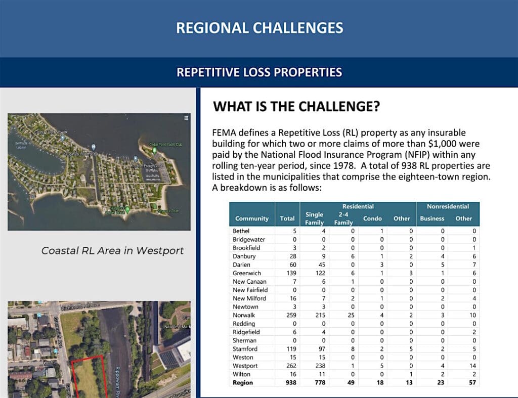
Westport has 1,338 flood policies in place, adding up to more than $413 million in coverage, according to the plan.
It also has the highest number of repetitive-loss properties in the region at 262.
A repetitive-loss property is defined by the federal government as “any insurable building for which two or more claims of more than $1,000 were paid by the National Flood Insurance Program (NFIP) within any rolling 10-year period, since 1978.”
Mozian pointed out that the town’s participation in the hazard mitigation planning, and in the National Flood Insurance Program Community Rating System, mean savings for Westporters.
“Policy holders get an automatic 10-percent reduction in their flood insurance, because of the efforts the town has made to go above and beyond the normal participation in the National Flood Insurance Program,” she said.
Discounts range from 5 percent to 45 percent, according the Federal Emergency Management Agency’s website, depending on how many flood-mitigation projects a community undertakes.
Mozian said the projects she mentioned could possibly boost the discount for Westport policyholders even further.
The hazard mitigation plan details threats posed by a variety of events — flooding, winter storms, tropical cyclones and hurricanes, tornadoes and high winds, thunderstorms, forest and wildland fires, drought, earthquakes, dam failure, terrorism and mass-casualty events.
Some good news for Westport is that earthquakes are not considered a significant threat.
”All areas of the Region are susceptible to earthquakes, although the likelihood of a damaging earthquake having its epicenter directly below the region is relatively small,” according to the plan.
“In general, the Region is likely to be part of a larger regional area affected by a damaging earthquake as opposed to individual municipalities being affected,” it says.
Tornados are also infrequent in the region, the report states. Sixteen have touched down in the WestCOG area in the last 70 years.
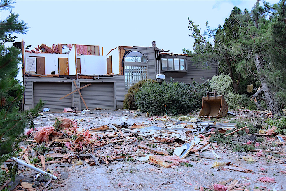
It does point out, however, that a waterspout came onto land at Saugatuck Shores on Aug. 4, 2020, damaging a house on Surf Road. It had winds up to 105 mph, according the National Weather Service.
Tornados in the region average out to one every 6.25 years.
“This is an example where working on a regional basis, we actually, I think, benefit collectively,” First Selectman James Marpe said.
“A lot of the challenges, from what I’ve learned over these years, that relate to flooding and wetlands areas, are generated in other parts of our region sometimes, so a coordinated effort along those lines is helpful,” he said.
“It’s a really fascinating document,” Selectwoman Melissa Kane said. “I really urge people to read it.” To view the WestCOG Multi-Jurisdictional Hazard Mitigation Plan, go to https://westcog.org/emergency-management/hazard-mitigation/


Recent Comments