
By John Schwing
WESTPORT — When Tropical Storm Henri breezed through southwestern Connecticut less than two weeks ago, many were relieved the region escaped the initial dire warnings about potentially severe damage.
Henri, which a day before landfall was a full-fledged hurricane, threatened Westport with torrential rain, gusting winds and storm-surge flooding. Thousands of power outages were predicted.
Local and state officials warned residents to be prepared for the worst. Emergency operations centers were activated, officials issued tips on how to stay safe during dangerous weather and updated locals on the storm’s impact. Residents stormed food, gas and hardware outlets to ride out the onslaught. Sand bags were piled high and flood gates erected to hold back flood waters.
“Prepare for the worst, hope for the best,” was the rallying cry for several days.
Then, well, nothing much happened.
Henri was a washout, at least for Westport and most of Fairfield County. Some complained the whole thing — forecasts, preparations, warnings — was overblown. When the storm shifted east, already downgraded to a tropical storm, the brunt was felt in eastern parts of the state and Rhode Island.
And now, with nowhere near the same fanfare, another storm is bearing down on the Westport region that could bring the heavy rain and thunderstorms that Henri didn’t.
Ida, after slamming Louisiana, heads toward southwestern Connecticut
That would be Hurricane Ida. The storm, which ravaged Louisiana and parts of the Gulf coast two days ago, has received plenty of media attention. Justifiably, since the storm knocked out power to almost the entire state, wrecked thousands of homes from flooding and wind damage, and left several people dead so far.
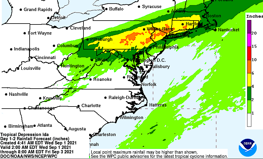
But Ida, although downgraded to a tropical depression, as of midday Wednesday still is packing plenty of rain and flooding potential. And now it’s boomeranging up from the Gulf Coast through the Ohio Valley — and heading Westport’s way.
The town has been under a “flash flood watch” issued by the National Weather Service since 8 a.m. Wednesday through 2 p.m. Thursday.
Today’s forecast: Heavy rain, possible thunderstorms and ‘isolated tornado’
The NWS midday forecast indicates that showers currently falling in Westport will continue throughout the day, becoming heavy by nighttime through late-morning Thursday.
Rainfall could amount to at least four inches, with the NWS “hazardous weather outlook” also warning, “There will be potential for thunderstorms late this afternoon into tonight, some of which may become severe with damaging winds.
“A brief isolated tornado cannot be ruled out,” the NWS statement adds.
The stormy weather should clear from the region by Thursday night, according to the weather service.
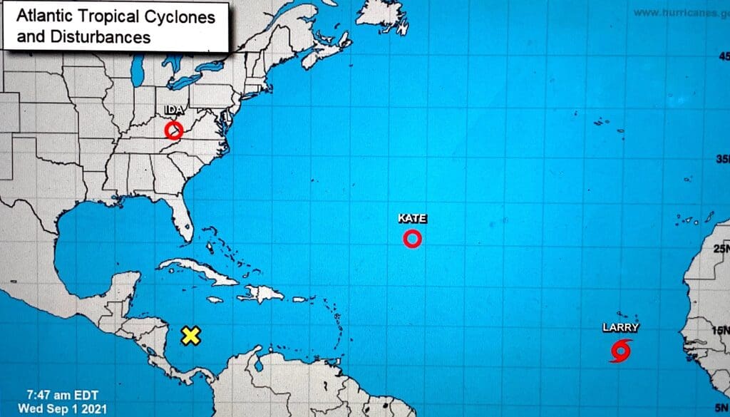
But all may not be “clear” for long as the National Hurricane Center said Wednesday the “Atlantic hurricane season shows no signs of slowing.”
And, sure enough, even as Westport awaits Ida’s arrival, Tropical Cyclone Kate and Tropical Storm Larry are churning in the Atlantic … heading toward parts uncertain.
For now.


Recent Comments