
By John Schwing
WESTPORT — The winter storm sweeping across the Northeast early Friday has — so far — failed to live up to Grinch-like predictions, but a day-long forecast of rain, gusty winds, coastal flooding and widespread power outages could change things.
And that’s before temperatures, which at 5 a.m. Friday were registering in the wildly un-wintry mid-50s range, plunge into the deep freeze with readings below 10 degrees Friday night.
At 6 a.m. Friday, more than 700 Westport Eversource customers had lost electric service, according to the power company, which was reporting more than 41,000 outages statewide at that hour. The outage toll is expected to rise throughout the day — just an hour earlier, only 68 Westporters were reported in the dark.
The power company on Thursday had projected that as many as several hundred thousand of its customers statewide could be blacked out before the storm winds down Friday night.
The state’s Emergency Operations Center will be activated at 7 a.m. Friday to monitor “the significant wind and rain storm that is anticipated to impact Connecticut over the next couple of days and then turn into ice as temperatures plummet this weekend,” according to an announcement from Gov. Ned Lamont.
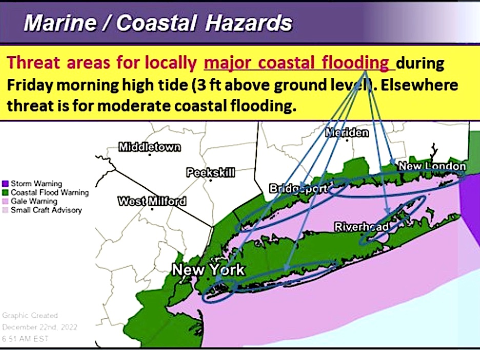
While rain and winds gusting as high 45 to 50 mph are expected to buffet southwestern Connecticut throughout most of Friday, the most immediate problem threatened by the storm Friday morning is flooding, according to the National Weather Service.
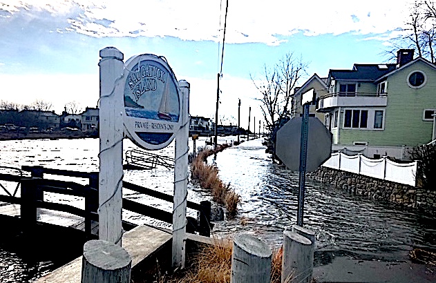
Flooding along coastal and low-lying areas of Westport and the rest of southern Connecticut is possible from 8 a.m. to 1 p.m. Friday, according to a “Coastal Flood Warning” issued by the NWS.
Flood levels from 1 to 3 feet above normal are possible in vulnerable areas, according to the weather service, with another round of flooding possible from 9 p.m. to midnight Friday night.
And, as unsettled conditions prevail throughout the day and temperatures start to slide sharply, thunderstorms are possible, the NWS says.
Still ahead is the weather shock predicted to grip the region by Friday nighttime as Fahrenheit readings crash 40-plus degrees, from the mid-50s Friday morning to below 10 degrees overnight into early Saturday.
The storm is expected to sweep out of the region early Saturday, and skies should be clear and frigid.
The high temperature Saturday is expected to be only about 20 degrees, with temperatures falling to 10 degrees overnight.
Sunday, Christmas Day, will be sunny again, but only slightly warmer, with the Fahrenheit reaching the mid-20s.
Emergency information
A list of emergency contact information for Westport, assembled by the local Emergency Management Team, can be found here.
Power outages can be reported online at Eversource.com or by calling 800-286-2000. Customers who signed up for the power company’s two-way texting feature can send a text to report an outage and receive outage updates as they happen.
John Schwing, the Westport Journal consulting editor, has held senior editorial and writing posts at southwestern Connecticut media outlets for four decades. Learn more about us here.


")

")

")
")

Recent Comments